


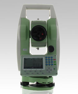
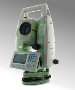
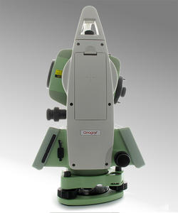
GEOGEX GX-TS30 Total Station, gives you precise distance and angles measurements and it is the perfect tool whenever the topographic works requires a light and fast machine, all day working in surveying jobs or construction works.
On-board field programs, included as standard, make GX-TS30 suitable for any construction site, cadastral, mapping and staking out, works. No limitation for distance measurements, up to 3.000 m with a single prism - 350 m reflectorless– and 2” as angular accuracy, always guarantee a reliable points calculation. It has been designed to hold out against rain and dust: the IP65 certification allows to go ahead with the survey.
|
KEY FEATURES:
|
 |
Dual-axis Compensation
The GX-TS30 is configured with an advanced dualaxis compensator for auto error elimination and auto accuracy compensation.
Absolute Encoding
The absolute encoding disk ensures high accuracy, efficiency and stable performance. Initialization is needless but to measure the angle immediately as the GX-TS30 is turned on. The azimuth information won’t be missed even the GX-TS30 is power-off unexpectedly.
High-performance MCU SMT32
The STM32 MCU based on ARM Cortex™-M processor enables the GX-TS30 has extra high processing speed and low-power consumption.
Bluetooth
The Bluetooth wireless technology makes GX-TS30 accessible to any data collector for real-time communication. The third party field software such as Carlson SurvCE is fully compatible with the GX-TS30.
Data Storage
Diversified data transfer options such as SD card, USB pen drive, mini-B interface.
Backlight
The display and keyboard with backlight for working in the dark.
Diagonal Eyepiece
Support optional diagonal eyepiece for observations at steep line of sight.
Calibration Software
The proprietary GEOGEX Calibration software is accessible for real-time diagnosis to ensure trouble-free operation.
Data Transfer Software
The proprietary GEOGEX data transfer software supports different type of output data format, which can be used in CAD processing software.
| Angle Measurement | |
| Measurement Method: | Absolute Encoding |
| Minimum Readout: | 1″/5″/10″ (0.3mgon/1.5mgon/3mgon) adjustable |
| Accuracy1: | 2” |
| Distance Measurement (with reflector) | |
| Single Prism3: | 3000m (9,842ft.) under good condition |
| Three Prisms3: | 6000m (19,685ft.) under good condition |
| Reflective Sheet: | 800m (2,624 ft.) |
| Accuracy: | 2 mm +2ppm |
| Measuring Time (Fine/Quick/Tracking)5: | 1.5s/1s/ 0.5s |
| Distance Measurement (without reflector) | |
| Reflectorless2 Range: | 350m (1,148 ft.) |
| Single Prism: | >7500m (24,606ft.) |
| Accuracy: | 3mm+2ppm |
| Measuring Time5: | 1.5s |
| Telescope | |
| Magnification: | 30X |
| Field of View: | 1°30′ (2.7m at 100m) |
| Minimum Focusing Distance: | 1.5m |
| Reticle: | Illuminated |
| Compensator | |
| System: | Single-axis liquid tilt sensor/Dual-axis (optional) |
| Working Range: | ±3′ |
| Setting Accuracy: | 1″ |
| Communication | |
| Bluetooth | |
| Interface: | Standard RS232, SD card4, USB pen drive, mini-B |
| Internal Data Memory: | Approx. 20,000 Points |
| Data Format: | ASCII |
| Operation | |
| Operation system: | Real-time Operating System |
| Display: | High resolution backlight black and white display with contrast adjustment/ Graphics: 280 x 160 pixels / Character: 6 lines x 25 characters |
| Keyboard: | 2 sides Alphanumeric backlit crystal keyboard |
| Laser Plummet | |
| Type: | Laser point, 4 brightness levels adjustment / Optical plummet (optional) |
| Centering Accuracy: | 1 mm at 1.5m instrument height |
| Power Supply | |
| Battery Type: | Rechargeable Li-ion battery |
| Voltage/Capacity: | ZBA-400: 7.4V (DC) / 3000mAh |
| Operating Time With ZBA-400: | Optimal 16 hours5 (Continuous angle measurement every 30 seconds) / 10 hours (typical) |
| Measuring Times: | Approx. 12000 times |
| Weight | |
| Weight (Incl. Battery & Tribrach): | Approx. 5.5kg (12.1lb.) |
| Environmental | |
| Operating Temperature: | -20°C ~ +50°C ( -4°F to +122°F) |
| Storage Temperature: | -40°C ~ +70°C (-40°F to + 158°F) |
| Dust&Water Proof (IEC60529 Standard)/Humidity: | IP65, 95%, non-condensing |